A Two-Map Afternoon: Compare One Region at Two Scales
A two-map afternoon helps you connect a regional map with a close view, revealing routes, shared places, and details each scale leaves out.
On a regional map, a community library may appear as a tiny mark beside a road; on a close map, its entrance, nearby crossing, and path to the bus stop can come into view. A two-map afternoon makes that change in scale the subject of a relaxed map-reading activity: compare the broad picture with a local view, then note which connections each reveals and which it cannot show.
The aim is not to decide which map is more accurate. Each is designed to make some relationships easy to see and others harder to notice. Looking between them can help you understand how neighbouring communities share places, routes, and services without mistaking a mapped symbol for the full experience of a place.
What should you choose before opening the maps?
Pick a small region you can describe without needing to cover a large area: perhaps two neighbouring villages, a town and its nearby neighbourhoods, or a cluster of streets around a shared hall. Choose one shared place as an anchor, such as a library, market square, playground, clinic, or community centre. The anchor gives your comparison a focus, but it need not be the only feature you notice.
Use two maps that cover the same general area at noticeably different scales. A regional road or topographic map can show the arrangement of settlements and their main links. A detailed street map, local map, or digital map zoomed in can show junctions, paths, buildings, and crossings. Check the map legend, scale bar, orientation, and date if provided. These details help explain what a map is intended to represent and how current its information may be.
Paper maps work well because you can lay them side by side and mark notes on a separate sheet. A phone or tablet offers convenient zooming, but keep the map view steady as you compare it; otherwise, a change in position can look like a change in scale. You do not need a ruler or specialist equipment. A pencil, notebook, and a place to sit are enough.
How can one invented afternoon unfold?
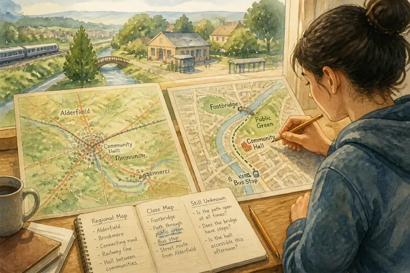
Imagine a clearly hypothetical situation: Mina wants to understand how the residents of two fictional neighbouring communities, Alderfield and Brookmere, might reach their shared community hall. She has a regional map showing both settlements, their connecting road, and a railway line. Her detailed map shows the hall’s surrounding streets, a footbridge, a bus stop, and a public green.
Mina begins with the regional map. She marks the two settlements, the hall’s approximate position, and the main routes between them. At this scale, the hall appears to sit between the communities, and the railway seems to be a prominent boundary. The regional view makes a broad relationship visible: the hall could serve people from both places, and the road offers an apparent link.
She writes down what the map actually supports and what it does not. It supports the observation that the hall lies between the mapped settlement areas and near a connecting route. It does not tell her how easy the route is to use, whether the road has a safe crossing, or whether the railway can be crossed nearby. Keeping those questions separate prevents a plausible-looking line from becoming an unsupported claim about access.
Next, Mina opens the detailed map around the hall. The railway is no longer the main story. A footbridge crosses a narrow watercourse nearby, and a path from Brookmere approaches the hall through the public green. From Alderfield, a street route reaches a bus stop and then turns toward the same entrance. The close view does not erase the regional connection; it shows some of the local pieces that might make it usable.
She adds a third column to her notes: “still unknown.” The map does not tell her whether the path is open at all times, whether the bridge has steps, or whether the hall is accessible during the afternoon she has in mind. Those are questions that might call for current local information or an in-person visit, not a guess based on map symbols. Her result is a more careful description: the two communities appear connected to one shared place through different mapped routes, while practical details remain to be checked.
This invented example is useful because the comparison changes the question. Instead of asking only “Where is the hall?”, Mina can ask “Which mapped links connect each community to it, and what would I still need to know before describing access?”
What changes when the scale changes?
Scale describes the relationship between distance on a map and distance on the ground. On a regional map, a shorter stretch of paper represents a larger area, so small features may be omitted or simplified. A close map represents a smaller area in greater detail, but it may not make the wider pattern between settlements obvious.
In practice, compare the maps across a few kinds of connection:
- Settlement pattern: Does the regional view make communities look separate, clustered, or arranged along a corridor? Does the close view show homes and local centres distributed differently?
- Routes: Which roads, rail lines, paths, or crossings are visible at each scale? Note when a route disappears from the regional map rather than assuming it does not exist.
- Shared places: Is a hall, library, park, or other common destination shown at both scales? The larger view may indicate its broader position, while the close view may reveal nearby approaches.
- Barriers and transitions: A river, steep slope, railway, or busy road may stand out regionally. At close scale, bridges, underpasses, gates, or gaps may alter how that feature divides or connects the area.
- Missing detail: Record what neither map answers. Map symbols do not necessarily convey opening hours, temporary closures, path conditions, or who can use a facility.
These comparisons are observations, not a scorecard. A regional map can be better suited to seeing relationships across several communities, while a detailed map can be more useful for tracing a local approach. Neither view alone can tell the whole story.
How can you keep the comparison fair?
Keep the same anchor point and general area in view as you switch maps. If the maps use different orientations, identify north or another recognisable feature before comparing routes. If one map is digital, check whether it is set to a road, terrain, or other view; the display style can affect which features stand out.
Use precise language in your notes. “The path is shown on the close map” is different from “the path is open.” “The hall appears near the boundary between the communities” is different from “both communities use it.” The first statements describe map evidence; the second make claims that may require local knowledge or current confirmation.
Map conventions also matter. A dotted line, shaded area, or coloured boundary can mean different things on different maps, so read the legend before interpreting it. When details depend on a map label, the map provider’s notes, or local rules, use those sources rather than treating a symbol as universal.
What questions help you read two maps together?
Why does a feature appear on one map but not the other?
Maps select and simplify details to serve different purposes and scales. A small footpath or building may be omitted from a regional view, while a local map may not show the region-wide pattern that gives it context.
Can a map show whether a shared place is accessible?
A map can show some approaches, crossings, and nearby transport links, but it may not describe surface conditions, opening times, step-free access, or temporary changes. Treat those as questions to verify through suitable current information.
Should I compare the distances by measuring them?
You can use the scale bars to estimate and compare mapped distances, provided the maps cover the same routes and the bars are legible. For this activity, the more useful observation may be whether the route’s relationship to settlements, barriers, and shared places changes in prominence.
What if the maps seem to contradict each other?
Check their dates, legends, coverage, and purpose before deciding that either is wrong. A newer local map may include a path that an older regional map leaves out, or different map styles may represent the same feature in different ways.
What should you take away from the afternoon?
Finish with a short note divided into three parts: connections visible on the regional map, connections visible on the close map, and questions neither view settles. Keep the wording observational. That record makes the comparison useful later without turning it into a claim about every resident’s route or experience.
For instance, a note might say that the regional map places two communities on opposite sides of a shared corridor, while the close view shows separate approaches to a local hall. It could also say that the maps do not establish whether the footpath is currently open. That is a complete result, not a failure to find an answer: the maps have clarified the pattern and drawn a boundary around what remains uncertain.
A two-map afternoon can be repeated with a different anchor, such as a market, park, or transit stop, but keep each comparison focused on one place and its links. The useful habit is to carry an observation across scales without carrying an assumption with it. A regional view helps you see how places relate; a close view helps you see some of the local connections that make those relationships legible.